From the Ground Up – Mountains and Streams
Picking up from last time, I’ll be talking a bit about mountains, and possibly streams as we turn the map from last time into something a bit more rugged, giving it both height and, possibly, depth.
The map I created last time works here still. We are going to make some adjustments to it later on, but the General form will do for what we are talking about.
Rise Above
Mountains are a little different than currents, both ocean and wind, but they are an important part in how the two interact with the rest of the world. While Wind currents and ocean currents, given unobstructed, unimpeded flow, would simply form circles around the earth, creating the perfect forms we talked about earlier. However, There are these massive obstructions to wind and ocean dictate climates, create both vegetation and its lack thereof, and redirect the currents, creating climates out of the expected for their locale.
Be aware, though, that even the choices you’ve made up until must remain flexible. Creating exactly what you want is going to be very difficult if you’re not willing to scrap everything that has been made until this point, and start again if you have a specific goal in mind.
Lets go back over the knowns of the land, so far:
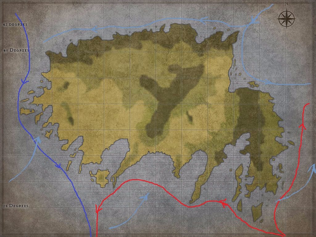
- its in the southern part of the northern hemisphere, from about 28 to 42 degrees. That is roughly from Orlando, FL to Rhode Island. should give us plenty of distance, but it also shows you the temperature differences.
- There is a cool current running down the west coast, starting in the north and getting colder as it rides south to warm up on the equator
- There us a warm current on the east coast, running up into the peninsula. Due to the fractured nature, it is likely to split, some of it going west along the southern coast before joining the west coast current going south again. the rest will hit a cool southern flowing current kicking out from the gulf in the north and be diverted east again.
This means that I’ll have a cooler, wet climate on the west, and a dryer, warmer climate on the east, unless I introduce something to change all that.
The Peaks
Mountains can do that. When cold and warm air meet, they tend to condense and form clouds. These clouds, high in the air, tend to stay there, condensed and ready to release rain, until acted upon by a force. In this case, the force we are talking about is mountains.
Mountains will slow down clouds, causing them to release their rain, reducing the rainfall on the opposite side of the mountains. This means, in essence, that deserts and dry areas must be bounded, on one side, buy mountains that winds are pushing over. Make sure you look at your currents chart, once you’ve created it, in order to place your mountains correctly in relation to the wind, cold air and warm air. While warm and cold air can converge to create condensation and clouds, Warm water is constantly evaporating and being carried into the air to form clouds as well. Be wary of creating mountains in the wrong locations.
To that point, I wanted to make sure there were a few high, dry areas, so after I created the map (see below) withe the currents, I edited my map to move some mountains, creating shadows.
The the inverse of the mountains creating dry areas on the opposite side of the wind, it creates great vegetated and wet lands on the same side of the mountains. These locales will be teeming with life. Swamps, rain forests (both temperate and tropical) and massive temperate forests will be located in and prior to the mountainous regions causing the dry areas.
So, now that you’ve placed your mountains in order to give yourself your forests and deserts, your dry regions and your wet, go ahead and put some more in. Put a ton more. You don’t need to be ancient Greece, but you’re going to want a lot of mountains unless you’ve got a special reason not to. With billions of years to work with, on a geologic scale, almost everywhere is at least hilly. Even as I look at my map, now, I want to put more, small, mountain ranges in it.
Ok. I added some, and I don’t feel as sparse.
Now that the mountains are there, We’re going to want to talk about why. Whooo boy. Looks like I’m gonna get to streams next time.
Tectonic
Lets take a look at the map I’ve made.
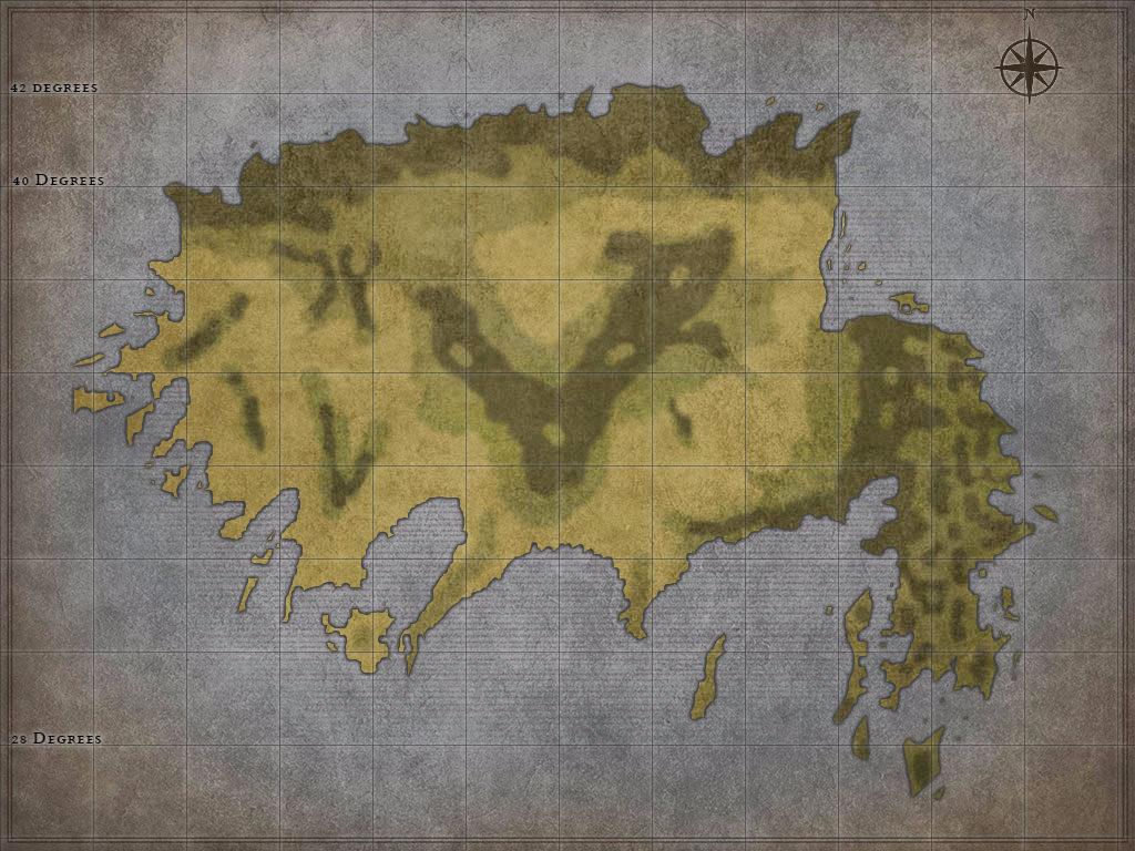
I’ve got two coastal ranges, a large central range, and a bunch of western ranges. I wanted to hit a bunch of cool concepts, so I took a couple and ran with them.
First, the Northern edge of the Island is a Coastal mountain region. This is where an oceanic plate is subducted under a continental plate, causing volcanic mountains. I liked the idea of a range, in the north, of volcanic mountains that bordered the sea. I don’t know what type of cool monsters I’ll have hear, but I am sure it will be awesome. This is going to be a dry and miserable area as the cool ocean current above it is going to lack evaporation from the north, and all the mountains to the south are going to provide a rain shadow to most of the inner portion of the island. Dry miserable uplands to the north, full of cold, hazardous volcanoes.
Its important to know why and how the volcanoes are here so that its all logically consistent. There will also be earthquakes here, due to the tectonic instability. Normally, these large, volcanic ranges cannot be found inland as they, generally, are caused by oceanic plates being melted while going under the lighter, less dense continental plates. These volcanic ranges are almost universally coastal.
Next, lets move to the other semi-coastal mountains. These are to the west, on the mountainous peninsula. These may require a bit of change, but I feel this is two plates smashing into each other. The massive island portion is careening into the smaller island plate, and creating a great, massive range of mountains in between. There will be a few, spotty volcanoes to the south, as the bay is subducted under the smaller, lighter continental Island plate.This small island is crumpling, made of a lighter material than the main plate, giving it its characteristic, near constant mountains in the north. I might add even more, I’m not sure even what I have is enough!
Next, I want to chat a tiny bit about two of the other types of mountains that we have here. neither of these are going to be currently active tectonic boundaries, but I do want to understand why there are mountains here. First, the 5 ranges wide west. I’m going to call these Ancient Plateau mountains. These are mountains that, ages and ages ago, were part of a massive plateau, or multiple plateaus, that have slowly weathered away due to erosion from streams and wind. Now, where there was once a massive uplands, there are only calm, hilly lands with random sections of hard, rough mountains poking their head up. Only the strongest, most durable rocks could persist through the erosion, Sand and sediment has settled in many of the areas, and the mountains are smaller and covered in soil, and therefore vegetation, spurred on by the wind and rains. While the peaks of the East and North mountains will likely be covered in snow and rocks, cutting into the heavens, the mountains here are shallow, rolling, rarely abrupt mountains covered in trees and plants from base to peak.
The last set of mountains is the central set. This seems like a pretty solid place to have my Massif based mountains. These giant structures are what is left of unimaginably large geologic structures. Volcanoes and tectonics on scales so large they are nearly unbelievable. This mountain range, I do believe, is going to be a volcanic shield, pushed up by the mantle billions of years ago, with jagged, sharp relief. when the volcano finally exploded, It did so from the lowlands in the north-center of the island, Thus, these mountains are a solid, curved surface of mountain on mountain stacked on top of each other for millions of years before being ground into the fertile, vegetated, yet still mineral intensive and extremely high plateau-mountains.
Well, Next time, we can tackle waterways, streams, gulfs and deltas. Let me know what you think of how the world is shaping out!